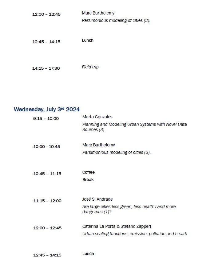
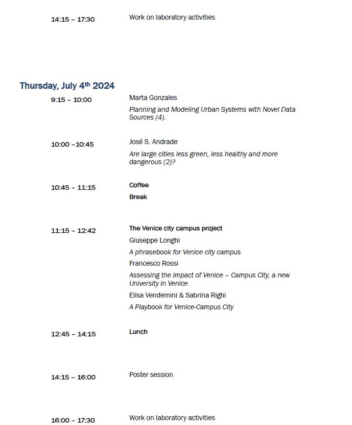
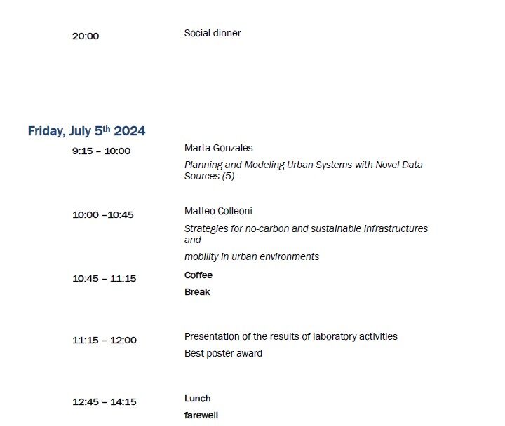
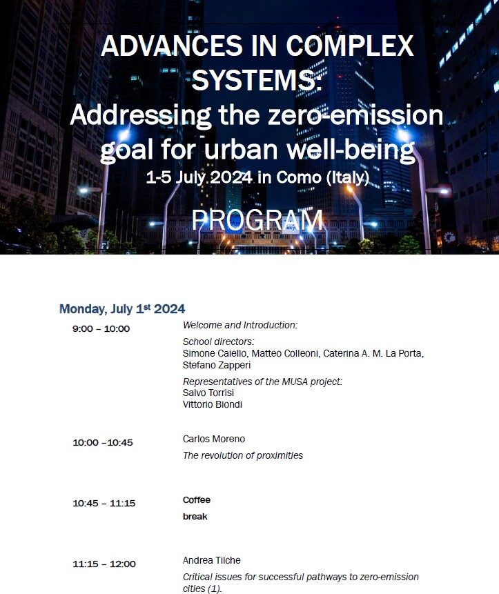
Program


Lecture titles & abstracts
José S. Andrade
Title
Are large cities less green, less healthy and more dangerous?
Abstract
In the first lecture, we initially explore how urban quality varies with city size, focusing on carbon dioxide emissions. Our bottom-up approach merges microscopic data on population and carbon dioxide emissions across the continental US. Initially, we aggregate nearby settlements into cities using the City Clustering Algorithm (CCA), which defines cities beyond their administrative boundaries. Subsequently, we employ data on CO2 emissions at a fine geographic scale to ascertain the total emissions for each city. We observe a superlinear scaling pattern, characterized by a power-law relationship between CO2 emissions and city population across all US cities. This remarkable finding implies that the higher productivity of larger cities comes with disproportionately higher emissions than smaller cities. Moreover, our findings significantly diverge from those based on the standard administrative definition of cities, such as the Metropolitan Statistical Area (MSA). In contrast, MSAs show isometric scaling of emissions, and we suggest this difference arises from the overestimated areas of MSAs. These results indicate that allometric studies using administrative boundaries to define cities might be affected by endogeneity bias. We also use similar methods and ideas to expand our analysis, investigating how city size affects lethal violence and public health in urban areas. Assessing the resilience of a road network is instrumental to improve existing infrastructures and design new ones. In the second lecture, we apply the optimal path crack model (OPC) to investigate the mobility of road networks and propose a new proxy for resilience of urban mobility. In contrast to static approaches, the OPC accounts for the dynamics of rerouting as a response to traffic jams. Precisely, one simulates a sequence of failures (cracks) at the most vulnerable segments of the optimal origin-destination paths that are capable to collapse the system. Our results with synthetic and real road networks reveal that their levels of disorder, fractions of unidirectional segments and spatial correlations can drastically affect the vulnerability to traffic congestion. By applying the OPC to downtown Boston and Manhattan, we found that Boston is significantly more vulnerable than Manhattan. This is compatible with the fact that Boston heads the list of American metropolitan areas with the highest average time waste in traffic. Moreover, our analysis discloses that the origin of this difference comes from the intrinsic spatial correlations of each road network. Finally, we argue that, due to their global influence, the most important cracks identified with OPC can be used to pinpoint potential small rerouting and structural changes in road networks that are capable to substantially improve urban mobility. Finally, we present evidence supporting the idea that human mobility in large cities can serve as a proxy for crime and investigate its effect on disease transmission.
Marc Barthelemy
Title
Parsimonious modeling of cities.
Abstract
Modelling the structure and evolution of cities is critical because policy makers need robust theories and new paradigms for mitigating various important problems such as air pollution, congestion, socio-spatial inequalities, etc. Fortunately and thanks to new technologies, the increased data available about urban systems opens the possibility of constructing a quantitative ‘science of cities’ with the aim of identifying and modelling essential phenomena in a parsimonious way. In these lectures, I will illustrate this approach on various aspects of cities comprising segregation, the dynamics of urban populations, and mobility in cities though car traffic and the structure of subway networks.
.
Matteo Colleoni
Title
Strategies for no-carbon and sustainable infrastructures and
mobility in urban environments
Abstract
The objective of the European climate law to achieve zero net emissions by 2050, in particular in the cities that are the largest emission centres, and even more so that of the Mission 100 climate neutral cities@2030 of bringing forward the decarbonisation targets to 2030, yes they are faced with obstacles that still limit their possibilities of implementation and make the activation of policies aimed at sustainable urban mobility increasingly urgent. The growing share of the population living in large urban areas makes this picture even more complex, since it brings with it a greater share of the mobile population, generally by private car, often with a significant age and level of pollution. Policies capable of reducing dependence on the car and increasing the diffusion and quality of infrastructures for active mobility are therefore necessary. These objectives can be achieved in different ways: leveraging limitation, transport integration and mobility management initiatives.
Marta Gonzales
Title
Planning and Modeling Urban Systems with Novel Data Sources
Abstract
My work explores predictive models for human mobility in urban systems, emphasizing the critical role of data and mobility metrics in their accuracy. Road usage patterns are analyzed, revealing a few driver sources significantly influencing major traffic flow, enabling a strategy for substantial travel time reduction. Another study identifies traffic collapse as a phase transition with three states and two distinctive transitions, marking the system’s breakdown. Percolation theory and the macroscopic fundamental diagram are applied to empirical traffic networks. Another lecture then demonstrates practical applications for sustainable transportation planning, utilizing phone-based travel demand and bike app data. The percolation theory helps prioritize bike paths based on potential demand, exemplified in Bogotá. Finally, I present a framework for facility allocation for the 15-minute city, with results suggesting a 50% reduction in travel costs through optimized facility redistribution. The findings provide a functional model for estimating the number of facilities required to achieve a desired average travel distance based on population distribution in a city.
Caterina La Porta & Stefano Zapperi
Title
Urban scaling functions: emission, pollution and health
Abstract
Urban scaling is widely used to characterize the population dependence of city indicators including greenhouse gas emission. Here we analyze the population dependence of CO2 and PM2.5 emissions and concentrations across all European cities. Our analysis reveals considerable variations in emissions among cities of comparable population size which are not captured by conventional urban scaling. We thus characterize these fluctuations by multiparameter scaling functions and multifractal spectral analysis. We find that the distributions of emissions and population is multifractal while that of air pollution is not, leading to non-trivial relations between emission and pollution in some large cities. We also analyze the impact of forests in curbing emissions and the impact of air pollution on health. Our work provides a detailed picture of the fluctuations in the scaling of urban metabolism in Europe and suggests a general strategy that goes beyond conventional urban scaling laws.
Carlos Moreno
Title
The revolution of proximities
Abstract
The Covid-19 crisis has shown the strength of cities because it is a systemic urban crisis of a sanitarian nature. Having to silence the city to avoid the spread of the virus shows the need to rethink our cities’ urban planning to favour economic, ecological and social value in the proximity. For facing against climate change in the long-term and COVID-19 in the short term, we need to radically change our urban lifestyle. Rethinking the long journeys in our cities and the concentrations associated with them is essential. We need to review our cities’ mono-specialized focal points and give greater impetus to the polycentric city. We have to go to the multipolar and multifunctional city. We need to provide extensive access to essential local services a priority, within a maximum distance of 10 to 15 minutes on foot or by bicycle, to create this new multi-center city. We called it in Paris ‘The City of proximities’, ‘The 15-Minute City‘.
Andrea Tilche
Title
Critical issues for successful pathways to zero-emission cities
Abstract
The European Commission, with its “Climate-Neutral and Smart Cities” Mission of Horizon Europe set the ambitious goal of delivering 100 climate-neutral cities by 2030. Cities play globally a central role in achieving the net-zero emission target necessary to stay within the warming limits of the Paris Agreement, and the European Mission, with its very challenging goal, launched a “race to the top”, with the clever idea that 100 different pathways (108 with 8 non-EU partner cities), with their errors and successes, may help a much larger group of not only European towns to design robust approaches to their own decarbonisation pathways. Buildings and transports are key areas. Beyond criticalities that depend on each city-specific features, many commonalities exist, and above all – true keystone of success – the relationship between the local political administration and the citizens.
The Venice city campus project
Giuseppe Longhi
Title
A phrasebook for Venice city campus
Abstract
The development of Venice city campus implies an adequate renewal and expansion of knowledge, able to face the current disruptive changes in the social, economic and planning fields. Hence a reflection on the history of design ‘phrasebooks’ and the proposal of a new ‘phrasebook’ able to generate symmetries between an analogue development of science and territory with a digital development, with the aim of implementing collective capabilities with the minimum of impact on natural resources.
Francesco Rossi
Title
Assessing the impact of Venice – Campus City, a new University in Venice
Abstract
In this talk, I will present the first outcomes of a modeling tool that we are developing in Iuav. The aim is to support planners, by assessing the impact of urban projects. The difficulty is to describe such impact at different geographical and time scales, through a large set of indicators, associated with demography, economic development, and climate risks. This general project is being first developed for “Venezia Città Campus”, a strategic project by Iuav that aims to increase the offer of higher education in Venice as a first step to a deeper revitalization of the area.
Elisa Vendemini – Sabrina Righi
Title
A Playbook for Venice-Campus City
Abstract
The Playbook for Venice city campus proposes the idea of an exponential development of knowledge consistent with a biological development of the city. The driving force of the project is didactic and research organization inspired by environmental and social tipping points, design innovation inspired by advanced sustainability criteria, relational innovation inspired by the construction of effective international scientific networks capable of counteracting environmental colonialism.
Laboratories & Hand on activities
.
Simone Caiello
Title
Objective and Subjective dimensions in urban accessibility perception
Abstract
Accessibility in urban realms is nowadays at core of the attention of the scientific and public debate. In particular after the recent experience of the COVID19 pandemic the relevance of proximity to urban opportunities rose as a pivotal goal for the management and transformations of cities. A continuously growing body of accessibility measures has appeared mainly addressing objective and physical characteristics of spaces (Caiello & Bottini, 2020). Besides these a relevant role is also played by subjective perceptions of (Lanza et al., 2023), that, if correctly integrated in the more “traditional” approaches, can provide crucial data for a better evaluation of accessibility. The laboratory will target both these dimensions experimenting quantitative GIS approach and more qualitative methods.
.
Luca Pappalardo
Title
Designing alternative routing strategies for urban well-being
Abstract
Navigating a city’s road network poses a unique challenge: what is best for a single driver may not align with the collective good. While individualized routes may optimize personal travel time, their aggregation often exacerbates citywide traffic congestion and, thus, CO2 emissions. The conundrum lies in steering drivers towards efficient routes thus fostering excessive concentration on specific roads. The challenge is finding a way to guide drivers to fast routes without everyone piling up on the same roads. This lab invites you to come up with a smart routing plan and dive into how it affects the city and its transportation system. Your goal? Make routes that get people where they are going on time without turning roads into big traffic jams.
.

